.png)
Understanding Level of Development (LOD) in 3D Laser Scanning for Effective BIM Applications
- Feb 18
- 4 min read
3D laser scanning has transformed how we capture and model physical spaces, providing detailed survey data that feeds directly into Building Information Modelling (BIM). Yet, not all projects require the same level of detail from this data. This is where the concept of Level of Development (LOD) becomes essential, and at Nirray Surveys we know the importance. Understanding LOD helps ensure that the survey output matches the needs of the project, avoiding wasted effort or insufficient detail.
This post explains what LOD means in the context of 3D laser scanning, why it matters for BIM, and how to determine the right level for different applications. Practical examples will clarify how LOD influences project outcomes and guide survey specifications.
What is Level of Development (LOD)?
LOD stands for Level of Development, a term used to describe the amount of detail and reliability included in a digital model or survey data. It defines how much information is available about an asset at a given stage, ranging from basic geometry to detailed specifications.
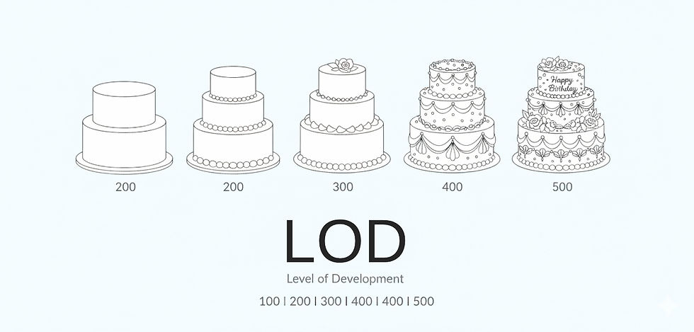
In BIM, LOD is often categorised into stages such as LOD 100, 200, 300, 400, and 500, each representing increasing detail and accuracy:
LOD 100: Conceptual model with approximate geometry and minimal detail.
LOD 200: Generalised model with approximate quantities and locations.
LOD 300: Precise geometry and accurate quantities suitable for coordination.
LOD 400: Detailed fabrication and assembly information.
LOD 500: As-built model verified in the field.
When applied to 3D laser scanning, LOD guides how much detail the scan data should capture and how it should be processed for BIM integration.

Why LOD Matters in 3D Laser Scanning for BIM
3D laser scanning produces vast amounts of data, capturing millions of points to represent surfaces and objects. Without a clear LOD, this data can be overwhelming or insufficient depending on the project’s needs.
Key reasons to define LOD include:
Efficiency: Scanning and processing data at a higher LOD than necessary wastes time and resources.
Accuracy: Too low an LOD may miss critical details, leading to errors in design or construction.
Communication: Clear LOD expectations ensure all stakeholders understand the level of detail delivered.
Cost control: Aligning LOD with project requirements prevents unnecessary expenses.
For example, a simple renovation might only require LOD 200 to capture general dimensions, while a complex retrofit or heritage building survey might need LOD 400 or 500 for detailed component modelling.
Determining the Right LOD for Your Project
Choosing the appropriate LOD depends on several factors:
1. Type of Asset
New construction: Often requires LOD 300 or higher for coordination and fabrication.
Existing buildings: May need LOD 400 or 500 to capture as-built conditions accurately.
Infrastructure: Bridges or tunnels might require specific LOD levels based on safety and maintenance needs.
2. Project Stage
Design phase: Lower LOD models can support early design decisions.
Construction phase: Higher LOD supports fabrication, installation, and quality control.
Operation and maintenance: As-built LOD 500 models help facility managers with accurate asset information.
3. Client and Stakeholder Requirements
Clear briefing from clients on the intended use of the data helps define the LOD. For example, a client focused on energy modelling may require different details than one focused on structural analysis.
4. Survey Scope and Budget
Higher LOD usually means more scanning time, data processing, and cost. Balancing scope and budget is essential to avoid over- or under-delivering.
Practical Examples of LOD in 3D Laser Scanning
Example 1: Office Refurbishment
A company refurbishing an office space needs to update the interior layout. The survey requires capturing walls, doors, and fixed furniture with enough detail to support design changes.
LOD required: 200 to 300
Details captured: Wall positions, door openings, ceiling heights
Outcome: Designers receive accurate dimensions without unnecessary detail on HVAC or electrical systems.
Example 2: Heritage Building Conservation
A conservation project on a historic building demands precise documentation of architectural features, materials, and structural elements.
LOD required: 400 to 500
Details captured: Ornamental details, material conditions, structural joints
Outcome: Conservation specialists get detailed as-built models to plan restoration work.
Example 3: Industrial Plant Upgrade
An industrial plant upgrade involves replacing equipment and piping. The survey must capture exact locations and dimensions of existing assets.
LOD required: 300 to 400
Details captured: Equipment geometry, pipe routing, connection points
Outcome: Engineers can design upgrades with confidence, reducing clashes and downtime.
Understanding and applying the correct Level of Development in 3D laser scanning ensures that BIM models are fit for purpose. It balances the need for detail with practical constraints like time and budget. By defining LOD clearly at the start, projects can avoid costly mistakes, improve accuracy, and deliver better outcomes.
Consider your project’s asset type, stage, and client needs carefully to select the right LOD. Communicate this clearly with your survey team and use appropriate tools to capture and process data. This approach will make your BIM applications more effective and reliable.


Comments