
.png)

LiDAR Technology
Lidar (LiDAR) is an acronym for "Light Detection and Ranging", and can be known as "Laser Scanning" or "3D Scanning" across various sectors.
The technology is based on emitting eye-safe laser beams to gauge range, distance and form characteristics that produces a 3D representation of the surveyed context.
Lidar technology is used in space, found on satellites, and is known as LITE "Lidar In-space Technology Experiment) for atmospheric studies.
Lidar is mainly adopted for surveying, security, autonomous vehicles and robotics, but can also be used in manufacturing, geomatics, mapping, crop mapping, meteorology, archaeology and many more.
Core Benefits
Accuracy
Lidar sensors boast considerable accuracy in metrology and distance ranging.
Distance Ranging
Lidar data outputs as volumetric information with range, scale and form.
Rapid Speed
Lidar laser beams detect near and distant objects and environments at rapid speeds.

It is important to understand the benefits of LiDAR surveillance applications in comparison to former systems such as CCTV and PIR detection methods.
Unlike CCTV cameras, Lidar is able to provide a higher accuracy of detection and situation awareness in 3D that can be measured or tracked in real-time. The use of Lidar is considerably more efficient by reducing the amount of detection and monitoring hardware required such as hardwired PIR's and Infrared Beam detectors required to protect a site, property or asset.
Unlike CCTV cameras, Lidar is able to provide a higher accuracy of detection and situation awareness in 3D that can be measured or tracked in real-time.
The use of Lidar is considerably more efficient by reducing the amount of detection and monitoring hardware required such as hardwired PIR's and Infrared Beam detectors required to protect a site, property or asset.
The data visualised by Lidar can determine the outline of a person, object or space. With intelligent integration, this can become an "automated security guard" with intelligence on object/person classification and contextual threat analysis.
The Lidar sensor can also produce a static 3D "Digital Twin" by determining differences between static and moving objects, and depending on the software involved, is intelligent to detect and record volumetric changes.
This takes principles from the use of Lidar for Laser Scanning and Reality Capture as seen in modern construction surveying and forensic investigation survey methods.
LiDAR Detection

VOLUMETRIC DETECTION
COMPREHENSIVE OBJECT CAPTURE
DATA CAN BE CAPTURED AT NIGHT
TRACKING AND GEO POSITIONING
3D COVERAGE AND ANALYSIS
HUMAN AND OBJECT RECOGNITION
PRODUCES A DIGITAL TWIN
Photogrammetry

LACK OF DEFINITION
NO POSITIONING OR DISTANCING
LIMITED COVERAGE AREAS
NO POSITIONING DATA
NO VOLUMETRIC DATA
LACK OF DISTANCE RESOLUTION
CAMERA NOT EFFECTIVE AT NIGHT
Lidar vs CCTV

Point Cloud Data
The output data from a Lidar sensor is denoted as "point-cloud" data. After the laser scanner has fired the laser beam at the object over millions of trajectories, it is possible to determine an objects 3D distance, form and scale.
This results in a three-dimensional point-cloud containing millions of points that can form an accurate representation of the environment captured. This information is captured in a three-dimensional format, and can also be examined in standard Architectural formats such as plan, section and elevation.
Some sensors combine RGB photographic imagery with point-cloud data sets, providing a fully three-dimensional depiction of the actual element including textures and colours. Point cloud viewers can also be provided to view data with parametric capabilities (to measure data accurately).
Live recordings of Lidar sensors can provide a constant stream of point-cloud information, and detection can be determined through volumetric changes.
In terms of safety, security and survey capture - volume change can evidence a risk factor present within an environment, leading to a quicker action response time.
Point Cloud Examples

Building Facade Scan - Example
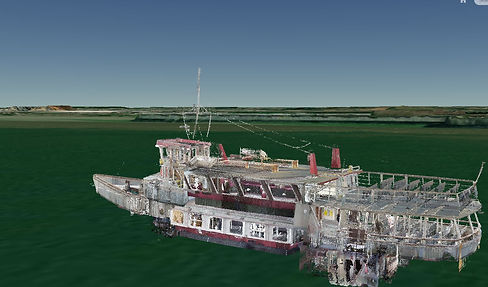
Marine Vessel Scan - Example
Detail captured through Lidar sensors presents a 3D digital representation of a vessel, and can be used to analyse the condition of the structure. This saves cost by reducing surveyor/investigator travel costs to the vessel.
Detail captured through Lidar sensors presents an accurate "digital-twin" of a building that is fully accurate in terms of Metrology. The survey provides a level of detail that is not physically possible to measure with other survey instrumentation.